Intelligent Conversational Research Assistant
Information Technology and Software
Intelligent Conversational Research Assistant (TOP2-288)
MATA - An Intelligent Assistant for the Earth Science Community
Overview
NASA Ames has developed a community-driven, context-aware intelligent research assistant system (MATA - Sanskrit name for the Earth) which is capable of engaging with users in a conversational manner using natural language dialogue, invoking external community-provided web services to obtain information or to perform actions, and vocalizes the responsive action back to the user. This novel, patented technology is an intelligent, virtual, personalized conversational research assistant system. Specifically designed for geospatial queries of Earth science data, this software application provides conversational computing, not just a conversational assistant. It is able to run on a personal computer or a mobile phone that facilitates user interaction with the system. This technology allows users to add new capabilities and new Application Programming Interfaces (APIs) so that it can be applied to a wide variety of applications.
The Technology
Previous virtual digital assistants (e.g., Siri®, Google Assistant®, Cortana®, Alexa®, etc.) allow users to speak requests to computers or mobile phones, which then perform speech-to-text recognition and execute web searches based on the content of the user's request. However, such systems cannot provide answers that are geospatially and space-time aware, for example, what the weather was like in San Francisco three days ago. In addition, typical virtual assistants only allow community users to indirectly influence system behavior through their queries.
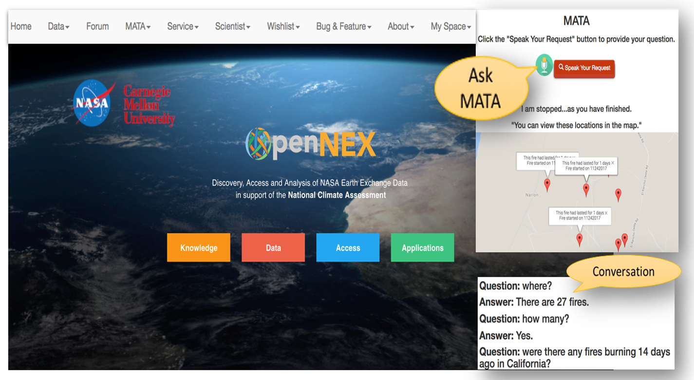
MATA provides a conversational assistant and associated computing to turn 40 years and hundreds of terabytes of Earth science of NASA Earth science data into usable knowledge. This system engages with users in an integrated, conversational manner using natural language dialogue, and invokes external web services, when appropriate, to obtain information and perform various actions on a variety of satellite and geospatial data to provide spatio-temporally aware answers. MATA is conversational computing, not just a conversational assistant.
Broadly, this technology takes a query, translates that query into to an intent, then that intent invokes the right capability, which in turn invokes the right APIs for computations that take milliseconds. MATA does not simply retrieve an answer from a database, but it intelligently answers a user's question within its specific context.


Benefits
- Users simply type a question or verbally ask the virtual digital assistant a question, and MATA will retrieve the appropriate data, perform any necessary computations, and respond in a conversational manner to the user
- Enhances access to NASA's Earth science data and research results
- Provides geospatially-aware answers to data queries
- Handles scientific questions by dedicated scientific procedures developed by domain experts
- Continuously integrates community intelligence, provides personalized research assistance in a conversational manner, and is geospatially and space-time aware
- Designed for ease of use and implementation
- Is scalable and its capabilities can be expanded easily by its users
- Uses open source software
- Prototyped in an operational environment
- Allows users to add new capabilities and new APIs and could be implemented for other big datasets
Applications
- Data Management
- Geospatial data
- Geospatial Analytics, and Weather Data & Forecasting (WD&F)
- Disaster management
|
Tags:
|
Similar Results

Flight Awareness Collaboration Tool (FACT)
The Flight Awareness Collaboration Tool (FACT) user interface is a quad design with four areas. The Primary Map View shows the US with several traffic and weather overlays. The Surface Map View displays the selected airport with information on runway conditions and other factors. The Information View has specific data from various sources about the area of interest. This view also has a built-in algorithm that predicts the impact of the forecast winter weather on airport capacity. The Communication View supports messaging within the geographically-dispersed team that is using FACT. When an airport is selected in the Primary Map View, the information presented in the Surface Map and Information Views is focused on that choice.
FACT is a web-based application using Node.js and MongoDB. It receives Java messages from the Federal Aviation Administration System Wide Information Management (SWIM) data repository. Data acquired from web pages and SWIM are tailored for FACTs Information View area. FACT is designed to reside on an existing workstation monitor to be put into use as needed.

Closed Ecological System Network Data Collection, Analysis, Control, and Optimization System
The technology relates generally to controlled ecosystems, and more particularly, to a Controlled Closed-Ecosystem Development System (CCEDS) that can be used to develop designs for sustainable, small-scale reproductions of subsets of the Earths biosphere and the Orbiting Modular Artificial-Gravity Spacecraft (OMAGS). The technology encompassing a CCEDS includes one or more a Closed Ecological Systems (CESs), each having one or more Controlled Ecosystem Modules (CESMs). Each CESM can have a biome containing at least one organism, and equipment comprising one or more of sensors, actuators, or components that are associated with the biome. A controller operates the equipment to effect transfer of material among CESMs to optimize one or more CESM biomes with respect to their organism population health, resilience, variety, quantities, biomass, and sustainability. A CES is a community of organisms and their resources that persist in a sealed volume such that mass is not added or removed. The mass (food/air/water) required by the CES organisms is continually recycled from the mass (waste) produced by the organisms. Energy and information may be transferred to and from a CES. CES research promises to become a significant resource for the resolution of global ecology problems which have thus far been experimentally inaccessible and may very well prove an invaluable resource for predicting the probable ecological consequences of anthropogenic materials on regional ecosystems. In order to create CESs that are orders of magnitude smaller than the Earth that can function without the Earth, the desired gravity level and necessary radiation shielding must be provided by other means. Orbiting Modular Artificial-Gravity Spacecraft (OMAGS) is a fractional gravity spacecraft design for CES payloads and is depicted in Figures below. In tandem, the CCEDS and OMAGS systems can be used to foster gravitational ecosystem research for developing sustainable communities in space and on Earth.

System for Incorporating Physiological Self-Regulation Challenge into Parcourse/Orienteering Type Games and Simulations
Although biofeedback is an effective treatment for various physiological problems and can be used to optimize physiological functioning in many ways, the benefits can only be attained through a number of training sessions, and such gains can only be maintained over time through regular practice. However, adherence to regular training has been a problem that has plagued the field of physiological self-regulation limiting its utility. As with any exercise, incorporating biofeedback training with another activity encourages participation and enhances its usefulness.

MERRA/AS and Climate Analytics-as-a-Service (CAaaS)
NASA Goddard Space Flight Center now offers a new capability for meeting this Big Data challenge: MERRA Analytic Services (MERRA/AS). MERRA/AS combines the power of high-performance computing, storage-side analytics, and web APIs to dramatically improve customer access to MERRA data. It represents NASAs first effort to provide Climate Analytics-as-a-Service.
Retrospective analyses (or reanalyses) such as MERRA have long been important to scientists doing climate change research. MERRA is produced by NASAs Global Modeling and Assimilation Office (GMAO), which is a component of the Earth Sciences Division in Goddards Sciences and Exploration Directorate. GMAOs research and development activities aim to maximize the impact of satellite observations in climate, weather, atmospheric, and land prediction using global models and data assimilation. These products are becoming increasingly important to application areas beyond traditional climate science.
MERRA/AS provides a new cloud-based approach to storing and accessing the MERRA dataset. By combining high-performance computing, MapReduce analytics, and NASAs Climate Data Services API (CDS API), MERRA/AS moves much of the work traditionally done on the client side to the server side, close to the data and close to large compute power. This reduces the need for large data transfers and provides a platform to support complex server-side data analysesit enables Climate Analytics-as-a-Service.
MERRA/AS currently implements a set of commonly used operations (such as avg, min, and max) over all the MERRA variables. Of particular interest to many applications is a core collection of about two dozen MERRA land variables (such as humidity, precipitation, evaporation, and temperature). Using the RESTful services of the Climate Data Services API, it is now easy to extract basic historical climatology information about places and time spans of interest anywhere in the world. Since the CDS API is extensible, the community can participate in MERRA/ASs development by contributing new and more complex analytics to the MERRA/AS service.
MERRA/AS demonstrates the power of CAaaS and advances NASAs ability to connect data, science, computational resources, and expertise to the many customers and applications it serves.

Automata Learning in Generation of Scenario-Based Requirements in System Development
In addition, the higher the level of abstraction that developers can work from, as is afforded through the use of scenarios to describe system behavior, the less likely that a mismatch will occur between requirements and implementation and the more likely that the system can be validated. Working from a higher level of abstraction also provides that errors in the system are more easily caught, since developers can more easily see the big picture of the system.
This technology is a technique for fully tractable code generation from requirements, which has an application in other areas such as generation and verification of scripts and procedures, generation and verification of policies for autonomic systems, and may have future applications in the areas of security and software safety. The approach accepts requirements expressed as a set of scenarios and converts them to a process based description. The more complete the set of scenarios, the better the quality of the process based description that is generated. The proposed technology using automata learning to generate possible additional scenarios can be useful in completing the description of the requirements.


